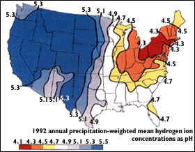
An isoplat map is a isoline map that uses contour lines to show variable changes of acidity in precipitation. This is an indicator of air pollution. The image above shows levels of acidity in the United States and was found on the United States Geology Society Website at http://pubs.usgs.gov/gip/acidrain/gifs/fig04.gif
No comments:
Post a Comment